
I've seen a few posts asking how far out is the blue water and what does the water look like at Falcon etc....
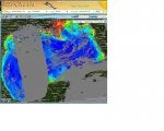
Right now things are changing very fast out there. We have large amounts of dirty water coming over from the Miss river, and lots of grass. This can be a very good thing or it can be a real tough thing for some who don't have an idea of what is going on before they depart. When I look at the latest shots from Rip Charts part of me goes oh man look at that incredible rip way out by BV and another part goes **** if that clean water would just push a little farther up by East breaks things would go off over there. If I didn't have Rip Charts and I just headed out to Tequila or the Hilltops I would be very disappointed to find them covered in dirty water. With the latest screen shot I would know, just a few more miles and I could be on the mother of all rips.
Anyway, my point is there is an incredible tool out there to help you save fuel and it can easily be used to help turn a tough trip into an incredible one. We used it last week and found one of the best rips I have seen in Texas about 30 miles south of BV and another great one several miles south of the Hilltops.
I have a feeling the first half of this summer we will continue to have lots of dirty water moving around with solid pushes of blue water in between. To me, that is a very good thing but, without Rip Charts it can be frustrating as well.
Maybe the guys from Rip Charts could put up the latest shot to illustrate.
Good luck everyone and remember there is a way to......:clover:"Know before you go.":clover:
 hwell: