2 Cool Fishing Forum banner
21 - 40 of 59 Posts
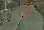
can anyone chime in on the area I have circled in red?
Unless something has changed the ramp at Shicke Point, pronounced Shacky's Point is private.

Depends on what size and style of boat you have as to where you can go. You can fish up in Carancahua Bay and even up into the river. Just watch the shorelines and you can see a lot of the reefs. The hook setter maps will show the deeper reef locations.

Just across the pass from Shicke Pint is an opening into Redfish Lake from the Matagorda Bay side. It's good to fish and has a lot of shell.

Run down the shoreline towards the fish hatchery and there are rolling guts all the way to shore that makes for good wade fishing. Hard sand bottom except up by the grass.

Past the Hatchery is Turtle Bay which will usually produce reds and trout. Flounder are good up shallow by the high bluffs to the left after you enter into the bay.

Going the other way towards Port Lavaca you can fish the shoreline between Shicke Point and Keller's Bay. You can go around Sand Point and into Kellers. Lots of grass and reds and decent trout there.

Again depending on the boat you run you can go anywhere that it can go from Shicke's.

TH
 
There is a public boat ramp on Hwy 35 just before you get to Cape Carancahua. They reworked it a couple of years ago and we see people put in there quite often.

There is also a public ramp at the end of 172 in Olivia. Just a couple of options.
 
Never been to West Matty but that's where I'll be going next. I'll be putting in my 14' tinner (25 HP Merc) at the Palacios boat ramp and go from there. This thread interests me as I need to learn where to go from there.

TWG
Better off unloading that boat at oyster lake and fishing there. North shoreline of west matagorda on a south wind at 10mph afternoon will eat that boat. Schicke boat ramps are private. So is port Altos boat ramp. There is a ramp on 35 but leaving out of there looks skinny as can be.

Sent from my SAMSUNG-SM-G900A using Tapatalk
I don't see a boat ramp there - ? If you mean from the shorline, I only have a 2WD truck so getting stuck is not on my to-do list. :biggrin:

TWG
 
There is a boat ramp off of Highway 35 on Carancahua. They've done a lot of work to it but it's still shallow.


Problem is unless you're going to fish the Crescent V (area from Wolf's Point to the river bridge, you have to fight the wind all the way across the bay to get anywhere.


TH
 

Attachments

Put small boat in at Carls Park on Tres Palacios river and run either way up river or down river to Bay rivers deep but gets shallow and trickey getting into bay..Carls Park is on FM521 off of 35 towards Nuke Plant 5m or so on 5 right
 
Best bet in that boat fishing out of palacios is to fish the east side and tres palacios bay. There you can fish the reefs in **** island or fish the mouth of redfish lake. Also run inside pelican slough and catch good reds but dont go to close to the left side. Its full of oysters all along the slough.
 
Better off unloading that boat at oyster lake and fishing there. North shoreline of west matagorda on a south wind at 10mph afternoon will eat that boat. Schicke boat ramps are private. So is port Altos boat ramp. There is a ramp on 35 but leaving out of there looks skinny as can be.

Sent from my SAMSUNG-SM-G900A using Tapatalk
I live in Cape Carancahua and see boats going out of that ramp all the time. If you can run in 3-5 feet of water you should be fine.

Not sure how deep it is right at the ramp, but it does get quite a bit of use.
 
Best bet in that boat fishing out of palacios is to fish the east side and tres palacios bay. There you can fish the reefs in **** island or fish the mouth of redfish lake. Also run inside pelican slough and catch good reds but dont go to close to the left side. Its full of oysters all along the slough.
That's plan A.

I have Redfish Lake marked but I do have to be careful crossing the bay with my "small" boat. Conditions will largely dictate where I can go. I've got really good range as far as fuel, and I can run pretty skinny.

Where is Pelican Slough?

TWG
 
TH,

Navionics has Pinkingtons Bayou named Pelican Slough on their maps.

It’s always been called Pilkington Bayou as far as TPWD is concerned as it’s the line that marks the legal shrimping waters. From Grassy Point to Pilkington Bayou north is not legal to take shrimp.


Sent from my iPhone using Tapatalk
 
TH,

Navionics has Pinkingtons Bayou named Pelican Slough on their maps.

It’s always been called Pilkington Bayou as far as TPWD is concerned as it’s the line that marks the legal shrimping waters. From Grassy Point to Pilkington Bayou north is not legal to take shrimp.

Sent from my iPhone using Tapatalk
Good info. I actually have that "pinned" on my Navionics APP. That's a place where I can get up into those marshes with my small boat.

TWG
 
Pilmkerton Bayou is just that... Pinkerton's bayou. I don't know why someone tried to rename it.


Good for reds up to the bridge if you want to soak dead bait but out in front to the south of the mouth is a really good shell reef that runs off of the bank.


I won a tournament with a trout and a red off of that reef.


Perfect for an aluminum boat.


If you run into Pinkerton's Bayou run towards College Port then angle into the mouth from that side (north east side).


TH


TH
 
Pilmkerton Bayou is just that... Pinkerton's bayou. I don't know why someone tried to rename it.

Good for reds up to the bridge if you want to soak dead bait but out in front to the south of the mouth is a really good shell reef that runs off of the bank.

I won a tournament with a trout and a red off of that reef.

Perfect for an aluminum boat.

If you run into Pinkerton's Bayou run towards College Port then angle into the mouth from that side (north east side).

TH
TH, 2 things.

"The bridge" - the one on 365??

Also, your last sentence above: it sounds like you are differentiating between Pelican Slough and Pinkerton's Bayou, correct? Are you saying to enter Pelican's Slough, then work my way up into Pinkerton's?

Also, I'm trying to understand where that shell reef is that you're referring to? Still in Tres Palacios Bay, or actually in or near that Bayou?

Thanks,
TWG
 
There is never been such thing as Pelican Slough. I’m not too sure where Navionics picked up that name. Like TH, I grew up there and it’s always been called Pinkington Bayou. TPWD is now calling it Pilkington but that’s always been the imaginary line from there to Grassy Point South is legal shrimping waters.

Not too sure on the reefs but TH will come in soon.

TH, do I have this right? You grew up there too and a lil older than me.

Wado, you gunna weigh in on this since all your people run outta Grassy Point?

Image


Sent from my iPhone using Tapatalk
 
21 - 40 of 59 Posts