
Anyone Recommend where to hit in palacios trying a new area out! Yes have boat and run skinny! Thanks
Mcrisler66
Fishing Palacios
1 reading
Mcrisler66
Discussion starter
1 post
·
Joined 2018
- Add to quote Only show this user
Anyone Recommend where to hit in palacios trying a new area out! Yes have boat and run skinny! Thanks
13,744 posts
·
Joined 2006
Lower West has been good for trout all spring... should still be some there. Another good area if the wind allows is the shoreline by the fish hatchery, but you need a lite North wind there.
572 posts
·
Joined 2017
Never been to West Matty but that's where I'll be going next. I'll be putting in my 14' tinner (25 HP Merc) at the Palacios boat ramp and go from there. This thread interests me as I need to learn where to go from there.
TWG
TWG
14,366 posts
·
Joined 2010
If you’re in Magnolia, I’ve been catching a few fish wading and from the pier between magnolia and Indianola.Never been to West Matty but that's where I'll be going next. I'll be putting in my 14' tinner (25 HP Merc) at the Palacios boat ramp and go from there. This thread interests me as I need to learn where to go from there.
TWG
23,548 posts
·
Joined 1998
In that size boat you need to stick with East Palacios Bay, Turtle Bay and Carancahua Bay, Tres Palacios and Carancahua rivers and Turtle Creek.Never been to West Matty but that's where I'll be going next. I'll be putting in my 14' tinner (25 HP Merc) at the Palacios boat ramp and go from there.
West Matagorda Bay is a very deep, very unforgiving bay that can remind you of the North Sea some days lol. So keep that in mind and it can change from mill pond slick to very rough in no time at all.
You can unload that size boat off of the point at Oyster Lake (4x4 truck is advisable) or any ramp in Palacios but I recommend the east side ramp. You can unload it at Jensen's Point on Turtle Bay as well.
http://www.stxmaps.com/go/palacios-fishing.html
TH
572 posts
·
Joined 2017
That's exactly my plan, suggested to me by a guide that knows that area very well.In that size boat you need to stick with East Palacios Bay, Turtle Bay and Carancahua Bay, Tres Palacios and Carancahua rivers and Turtle Creek.
West Matagorda Bay is a very deep, very unforgiving bay that can remind you of the North Sea some days lol. So keep that in mind and it can change from mill pond slick to very rough in no time at all.
You can unload that size boat off of the point at Oyster Lake (4x4 truck is advisable) or any ramp in Palacios but I recommend the east side ramp. You can unload it at Jensen's Point on Turtle Bay as well.
http://www.stxmaps.com/go/palacios-fishing.html
TH
I don't have a 4x4 so I'll put in at the Palacios public boat ramp.
Is there a ramp at Jensen's Point?
TWG
210 posts
·
Joined 2014
How long of boat ride is it if launching out Palacios and running out to Greens?
429 posts
·
Joined 2017
I can make it out yonder from the east bay ramp in about 30 min depending on swell.
Be careful around Oliver (**** Island), just b4 Hotel Point (there’s a pillon sticking up about 1’ from old well), and halfmoon reef area. Do NOT run across HMR. I have a Mowdy 22v and I have bumped my TM while drifting across it.
There may be enough water between the east end of it and the Palacios Point shire line but I wouldn’t bet a lower unit on it unless I knew a deep route. Best to navigate around west end of HMR unless there’s a salty dawg that can school us otherwise. I used to oyster that shoreline when I was a teenager and there’s a darn good reef that runs down that shore line from Hotel Point to Palacios Point. There’s an old tripod sticking up there and that reef has a big lump that runs all the way down it. We used to have to get 20 sacks on the bow in order to get the stern up before we could get on top of it and over into the gut.
Once ya get over to greens be careful as there’s a good bar there. I was able to troll motor over it on a high tide but my buddy in his 24 HO couldn’t get over it.
I ain’t run up into Greens yet but I sure wanna follow someone in there one day. I wanna see if I can get to the duck camp in there without tearing up the bottom.
![Image]()
Sent from my iPhone using Tapatalk
Be careful around Oliver (**** Island), just b4 Hotel Point (there’s a pillon sticking up about 1’ from old well), and halfmoon reef area. Do NOT run across HMR. I have a Mowdy 22v and I have bumped my TM while drifting across it.
There may be enough water between the east end of it and the Palacios Point shire line but I wouldn’t bet a lower unit on it unless I knew a deep route. Best to navigate around west end of HMR unless there’s a salty dawg that can school us otherwise. I used to oyster that shoreline when I was a teenager and there’s a darn good reef that runs down that shore line from Hotel Point to Palacios Point. There’s an old tripod sticking up there and that reef has a big lump that runs all the way down it. We used to have to get 20 sacks on the bow in order to get the stern up before we could get on top of it and over into the gut.
Once ya get over to greens be careful as there’s a good bar there. I was able to troll motor over it on a high tide but my buddy in his 24 HO couldn’t get over it.
I ain’t run up into Greens yet but I sure wanna follow someone in there one day. I wanna see if I can get to the duck camp in there without tearing up the bottom.

Sent from my iPhone using Tapatalk
572 posts
·
Joined 2017
O&G,I can make it out yonder from the east bay ramp in about 30 min depending on swell.
Be careful around Oliver (**** Island), just b4 Hotel Point (there’s a pillon sticking up about 1’ from old well), and halfmoon reef area. Do NOT run across HMR. I have a Mowdy 22v and I have bumped my TM while drifting across it.
There may be enough water between the east end of it and the Palacios Point shire line but I wouldn’t bet a lower unit on it unless I knew a deep route. Best to navigate around west end of HMR unless there’s a salty dawg that can school us otherwise. I used to oyster that shoreline when I was a teenager and there’s a darn good reef that runs down that shore line from Hotel Point to Palacios Point. There’s an old tripod sticking up there and that reef has a big lump that runs all the way down it. We used to have to get 20 sacks on the bow in order to get the stern up before we could get on top of it and over into the gut.
Once ya get over to greens be careful as there’s a good bar there. I was able to troll motor over it on a high tide but my buddy in his 24 HO couldn’t get over it.
I ain’t run up into Greens yet but I sure wanna follow someone in there one day. I wanna see if I can get to the duck camp in there without tearing up the bottom.
![Image]()
Sent from my iPhone using Tapatalk

"Greens"?
TWG
3,760 posts
·
Joined 2005
I run between halfmoon and the shoreline all the time. No big deal. Just stay outside of the can bouys marking the reef and you will be fine. There is plenty of water thru there.
572 posts
·
Joined 2017
Glenn,
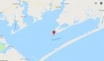
Is this Half Moon one of the small islands inside of **** Island Bay? Trying to get my bearings.
Thanks,
TWG
Is this Half Moon one of the small islands inside of **** Island Bay? Trying to get my bearings.
Thanks,
TWG
23,548 posts
·
Joined 1998
12 miles.How long of boat ride is it if launching out Palacios and running out to Greens?
No Half Moon Reef is off of Palacios Point.Is this Half Moon one of the small islands inside of **** Island Bay? Trying to get my bearings.
TH
Attachments
-
 36.8 KB Views: 976
23,548 posts
·
Joined 1998
He means Green's Bayou on the south shoreline of West Matagorda Bay. Between the big jetties and Matagorda.
There is plenty of water between Palacios Point and Half Moon Reef, that's how we run to the south shoreline.
The can buoys that used to mark the end of the reef on the Palacios Point side were not there the last few trips we made that way so be advised.
Yes there is a ramp at the end of the blacktop that leads from Highway 35 to Jensen's Point.
TH
There is plenty of water between Palacios Point and Half Moon Reef, that's how we run to the south shoreline.
The can buoys that used to mark the end of the reef on the Palacios Point side were not there the last few trips we made that way so be advised.
Yes there is a ramp at the end of the blacktop that leads from Highway 35 to Jensen's Point.
That tripod marks where the old ICW went through before it was moved to the present location and yes that's a good shell reef there and is especially good fishing in the winter. If you'll look towards Oyster Lake when you're running by that tripod you can see the old ICW channel.There’s an old tripod sticking up there and that reef has a big lump that runs all the way down it.
TH
3,760 posts
·
Joined 2005
They have all been replaced.The can buoys that used to mark the end of the reef on the Palacios Point side were not there the last few trips we made that way so be advised.
178 posts
·
Joined 2005
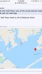
Thanks for getting this thread going, I have been trying to get my bearings around this area for a little while now. The STXMAP website is pretty helpful, just keep getting a lot of ads taking up the view.
Let’s see if my screenshot works, but can anyone chime in on the area I have circled in red? From the looks of it, the ramp is called Schicke Point. Wondering what I can hit from there and any insight about trrrain...
Thanks
Let’s see if my screenshot works, but can anyone chime in on the area I have circled in red? From the looks of it, the ramp is called Schicke Point. Wondering what I can hit from there and any insight about trrrain...
Thanks
Attachments
-
 80.8 KB Views: 747
49 posts
·
Joined 2017
PM me.Thanks for getting this thread going, I have been trying to get my bearings around this area for a little while now. The STXMAP website is pretty helpful, just keep getting a lot of ads taking up the view.
Let's see if my screenshot works, but can anyone chime in on the area I have circled in red? From the looks of it, the ramp is called Schicke Point. Wondering what I can hit from there and any insight about trrrain...
Thanks
23,548 posts
·
Joined 1998
Unless something has changed the ramp at Shicke Point, pronounced Shacky's Point is private.can anyone chime in on the area I have circled in red?
Depends on what size and style of boat you have as to where you can go. You can fish up in Carancahua Bay and even up into the river. Just watch the shorelines and you can see a lot of the reefs. The hook setter maps will show the deeper reef locations.
Just across the pass from Shicke Pint is an opening into Redfish Lake from the Matagorda Bay side. It's good to fish and has a lot of shell.
Run down the shoreline towards the fish hatchery and there are rolling guts all the way to shore that makes for good wade fishing. Hard sand bottom except up by the grass.
Past the Hatchery is Turtle Bay which will usually produce reds and trout. Flounder are good up shallow by the high bluffs to the left after you enter into the bay.
Going the other way towards Port Lavaca you can fish the shoreline between Shicke Point and Keller's Bay. You can go around Sand Point and into Kellers. Lots of grass and reds and decent trout there.
Again depending on the boat you run you can go anywhere that it can go from Shicke's.
TH
14,366 posts
·
Joined 2010
There is a public boat ramp on Hwy 35 just before you get to Cape Carancahua. They reworked it a couple of years ago and we see people put in there quite often.
There is also a public ramp at the end of 172 in Olivia. Just a couple of options.
There is also a public ramp at the end of 172 in Olivia. Just a couple of options.
23,548 posts
·
Joined 1998
There is a boat ramp off of Highway 35 on Carancahua. They've done a lot of work to it but it's still shallow.
Problem is unless you're going to fish the Crescent V (area from Wolf's Point to the river bridge, you have to fight the wind all the way across the bay to get anywhere.
TH
Problem is unless you're going to fish the Crescent V (area from Wolf's Point to the river bridge, you have to fight the wind all the way across the bay to get anywhere.
TH
Attachments
-
 100.3 KB Views: 759
7,717 posts
·
Joined 2008
Put small boat in at Carls Park on Tres Palacios river and run either way up river or down river to Bay rivers deep but gets shallow and trickey getting into bay..Carls Park is on FM521 off of 35 towards Nuke Plant 5m or so on 5 right
27 posts
·
Joined 2015
Best bet in that boat fishing out of palacios is to fish the east side and tres palacios bay. There you can fish the reefs in **** island or fish the mouth of redfish lake. Also run inside pelican slough and catch good reds but dont go to close to the left side. Its full of oysters all along the slough.
572 posts
·
Joined 2017
That's plan A.Best bet in that boat fishing out of palacios is to fish the east side and tres palacios bay. There you can fish the reefs in **** island or fish the mouth of redfish lake. Also run inside pelican slough and catch good reds but dont go to close to the left side. Its full of oysters all along the slough.
I have Redfish Lake marked but I do have to be careful crossing the bay with my "small" boat. Conditions will largely dictate where I can go. I've got really good range as far as fuel, and I can run pretty skinny.
Where is Pelican Slough?
TWG
23,548 posts
·
Joined 1998
Have no clue. Probably just a name someone gave to a place that already has a name.Where is Pelican Slough?
I've been fishing that area for over 50 years and have never heard of it.
TH
27 posts
·
Joined 2015
Sorry didnt check this in awhile. O&G posted a map of it. I use navionics now so I just went with that name.
429 posts
·
Joined 2017
TH,
Navionics has Pinkingtons Bayou named Pelican Slough on their maps.
It’s always been called Pilkington Bayou as far as TPWD is concerned as it’s the line that marks the legal shrimping waters. From Grassy Point to Pilkington Bayou north is not legal to take shrimp.
Sent from my iPhone using Tapatalk
572 posts
·
Joined 2017
Good info. I actually have that "pinned" on my Navionics APP. That's a place where I can get up into those marshes with my small boat.TH,
Navionics has Pinkingtons Bayou named Pelican Slough on their maps.
It’s always been called Pilkington Bayou as far as TPWD is concerned as it’s the line that marks the legal shrimping waters. From Grassy Point to Pilkington Bayou north is not legal to take shrimp.
Sent from my iPhone using Tapatalk
TWG

23,548 posts
·
Joined 1998
Pilmkerton Bayou is just that... Pinkerton's bayou. I don't know why someone tried to rename it.
Good for reds up to the bridge if you want to soak dead bait but out in front to the south of the mouth is a really good shell reef that runs off of the bank.
I won a tournament with a trout and a red off of that reef.
Perfect for an aluminum boat.
If you run into Pinkerton's Bayou run towards College Port then angle into the mouth from that side (north east side).
TH
TH
572 posts
·
Joined 2017
TH, 2 things.Pilmkerton Bayou is just that... Pinkerton's bayou. I don't know why someone tried to rename it.
Good for reds up to the bridge if you want to soak dead bait but out in front to the south of the mouth is a really good shell reef that runs off of the bank.
I won a tournament with a trout and a red off of that reef.
Perfect for an aluminum boat.
If you run into Pinkerton's Bayou run towards College Port then angle into the mouth from that side (north east side).
TH
"The bridge" - the one on 365??
Also, your last sentence above: it sounds like you are differentiating between Pelican Slough and Pinkerton's Bayou, correct? Are you saying to enter Pelican's Slough, then work my way up into Pinkerton's?
Also, I'm trying to understand where that shell reef is that you're referring to? Still in Tres Palacios Bay, or actually in or near that Bayou?
Thanks,
TWG
429 posts
·
Joined 2017
There is never been such thing as Pelican Slough. I’m not too sure where Navionics picked up that name. Like TH, I grew up there and it’s always been called Pinkington Bayou. TPWD is now calling it Pilkington but that’s always been the imaginary line from there to Grassy Point South is legal shrimping waters.
Not too sure on the reefs but TH will come in soon.
TH, do I have this right? You grew up there too and a lil older than me.
Wado, you gunna weigh in on this since all your people run outta Grassy Point?
![Image]()
Sent from my iPhone using Tapatalk
Not too sure on the reefs but TH will come in soon.
TH, do I have this right? You grew up there too and a lil older than me.
Wado, you gunna weigh in on this since all your people run outta Grassy Point?

Sent from my iPhone using Tapatalk
572 posts
·
Joined 2017
WT,
There are no roads to get to the mouth of this. Some private roads are somewhat close, but - private. To get to this place on foot you'd have to hoof it a long way, through some harsh swamp. You'd probably sink up to your waist trying. Need a small boat or kayak.
TWG
There are no roads to get to the mouth of this. Some private roads are somewhat close, but - private. To get to this place on foot you'd have to hoof it a long way, through some harsh swamp. You'd probably sink up to your waist trying. Need a small boat or kayak.
TWG
23,548 posts
·
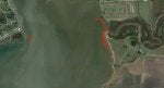
Joined 1998
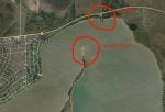
In the picture you'll see Grassy Point designated by the letters GP. Across the bay you'll see what has been the best way to enter the Bayou and south of the bayou you'll see a red line that shows where the shell reef is located.
There is no differentiation between the two as there is no Pelican Bayou in Palacios.
And yes that's the bridge that I'm talking about.
TH
There is no differentiation between the two as there is no Pelican Bayou in Palacios.
And yes that's the bridge that I'm talking about.
TH
Attachments
-
 62.4 KB Views: 499
23,548 posts
·
Joined 1998
I'll add that the fun thing about East Tres Palacios Bay is that you can explore the shore on both sides of the bay up to the mouth of the river and find reefs and places that hold fish.
For a live bait fisherman, reds, drum, flounder, trout can all be caught easily with shrimp under a popping cork.
Have fun there. The east shoreline is a haven when the wind is up and West Matagorda is angry.
TH
For a live bait fisherman, reds, drum, flounder, trout can all be caught easily with shrimp under a popping cork.
Have fun there. The east shoreline is a haven when the wind is up and West Matagorda is angry.
TH
572 posts
·
Joined 2017
TH,
I owe you a nice cold beer. Thanks for all the input you have offered.
The current Google Satellite image shows that shell reef very nicely when you zoom in.
TWG
I owe you a nice cold beer. Thanks for all the input you have offered.
The current Google Satellite image shows that shell reef very nicely when you zoom in.
TWG
23,548 posts
·
Joined 1998
Glad I could help. Maybe go with us one day and I'll show you some easy places for you to catch fish out of your boat.
TH
TH
572 posts
·
Joined 2017
I will take you up on that for sure.Glad I could help. Maybe go with us one day and I'll show you some easy places for you to catch fish out of your boat.
TH
Need to get my TM purchased and installed then I'll be ready.
TWG
-
?
-
?
-
?
-
?
-
?
-
?
-
?
-
?
-
?
-
?
-
?
-
?
-
?
-
?
-
?
-
?
-
?
-
?
-
?
-
?
- posts
- 7.4M
- members
- 121K
- Since
- 2004
A forum community dedicated to anglers in the Texas area. Come join the discussion about fishing guides, bait, safety, gear, tackle, tips, reviews, accessories, classifieds, and more!


